July 31, 2015

Battlecreek Falls Hike

Located east of Pleasant Grove, this is a great trail for kids and families. It's relatively short and ends at a spectacular waterfall.
Distance: About 1.1 miles round-trip
Elevation Gain: 465 feet
Hiking Time: 30 minutes-1 hour 

Driving Directions: From the town of Pleasant Grove, follow 200 South to the east side of town. The street is also known as Battle Creek Drive and it dead-ends at the trailhead. If coming from Salt Lake, take I-15 to Exit 275.   
 
 
I'm trying to find new trails outside of the Salt Lake Valley, and one day had to go to American Fork for an appointment so I looked up trails that were nearby. We found Battle Creek Falls trail and decided to try it out. I'm glad we did! It was a fun short and easy hike, ending at a waterfall.
 
History: Battle Creek is named after the first battle between Mormon settlers and the Native American Ute tribe. a small group of Timpanogots Indians were attacked by a Mormon militia on March 5th, 1849.
 
I love telling the history of the hikes we go on to my kids. It's a fun history lesson for them!
 
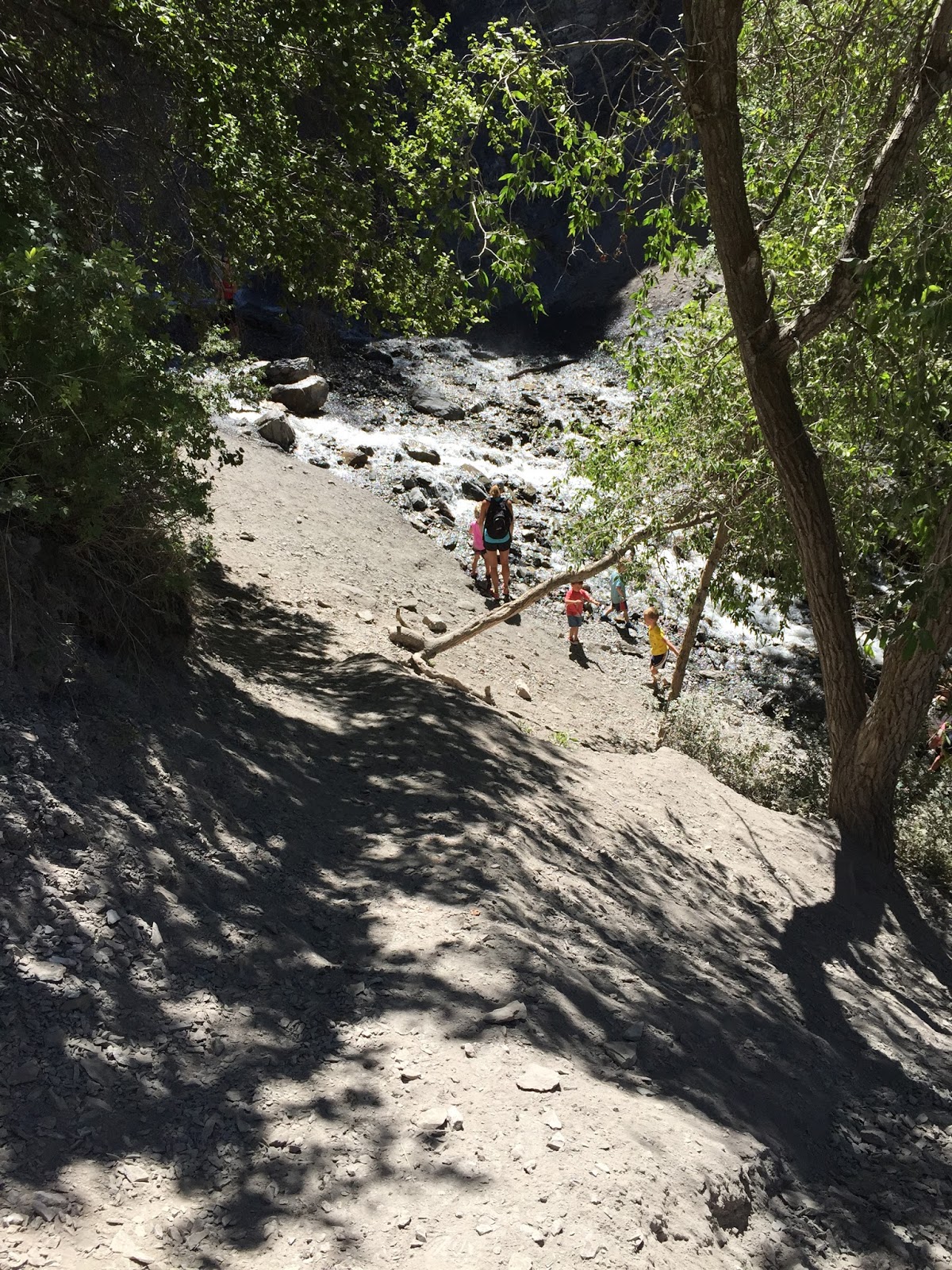
We did this hike in July mid-day, which wasn't the best choice, but it's when we happened to be down in that area. There wasn't much shade so it was a pretty hot hike, I'd recommend doing it earlier or later in the day during the Summer. This would make a great Spring and Fall hike as well.
 
The trail started out relatively flat and wide along the trail. 
 
 
After a short walk we made it to the Falls. In the Spring when the runoff is in full force, the falls is split into a double waterfall.
 
The spray from the waterfall felt great after our hot hike! 
 
 
We saw a beautiful butterfly.


Trying to get a picture of the 3 of us with the falls in the background wasn't easy!
 
Of course we found a shady spot by a boulder to have our snacks. We always pack snacks!
Tip: Freeze string cheese the night before then pack it on your hike, by the time you eat it it's thawed but still cold.


Beautiful views of Utah Lake below us.
 
 
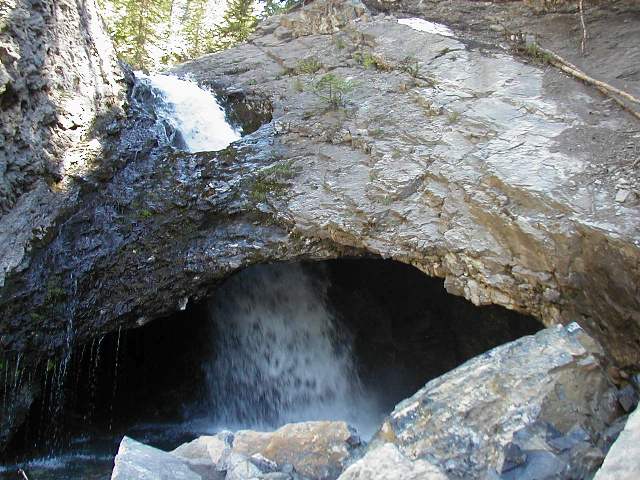
We spotted a fun little cave along the trail.
 
 
Another perk of this hike is the spectacular view of Mt. Timpanogos.
 
It's always a sign you've had a good hike when little ones fall asleep! She fell asleep just before we got to the car!

This was a great hike. We had a fun time on our July hike, I'd like to do this hike again in the Fall when it's a little cooler and the leaves are changing colors.

June 30, 2015

Ensign Peak

Ensign Peak is one of the most well-known and most popular hikes along the Wasatch Front. A quick hike to an overlook above the State Capitol building and downtown Salt Lake City, it provides excellent views of the entire valley. 

Distance: About 1 mile round-trip
Elevation Gain: 429 feet
Hiking Time: 30 minutes-1 hour 
Best times of year: Spring and Fall. There is little to no shade along the trail so if you do this hike in Summer, start early or go late!

Driving Directions: Go to the Utah State Capitol Building and head east around it on East Capitol Boulevard. Continue uphill east, and either Edgecombe Drive or Ensign Vista Drive will take you to the trailhead on Churchhill Drive, as part of the Ensign Peak Nature Park. 


History of Ensign Peak: On July 26, 1847, two days after the Mormon Pioneers entered the Salt Lake Valley, Brigham Young and a group of his followers climbed to the top of this mountain to survey the valley. One of them declared the peak Ensign Peak.


The trail up Ensign Peak is short and steep. There is a small park with benches at the trail head, but there are NO RESTROOMS.


This is a great hike for families. I did it with my two little ones, ages 4 and 2. I carried my 25 pound two year old on my back the whole way. My 4 year old was able to walk pretty much the entire time, although we were going pretty slow by the end.

The trail immediately offers great views of the Salt Lake Valley and the mountains. On clear days, you can see the length of the entire valley, clear down to the Point of the Mountain. 


At the top is an historical marker that stands tall and provides a small amount of shade. There are bars at the top to keep little ones in the area, but keep a close eye on them at all times since they can easily squeeze through these bars.

Bring plenty of water and a snack for the top. You've worked hard to get there! 


This particular time we went, we started at 10:00 am in June and it got hot very quickly. I would recommend starting closer to 8:00 am in the Summer or do this hike in Spring or Fall when the temperature isn't too hot or cold.


I did this hike with some youth in our church group in the evening as well. It's a great sunset hike, just make sure you bring flashlights to make it down safely. 


Summary: I love this hike. It's one of the shortest and easiest hikes to do with little ones (under age 5). Without kids, it will take roughly 30 minutes to reach the top, but with little kids I would plan on a full hour to make it to the top. Make sure you and your kids use the restroom before leaving home as there are no public restrooms at the trail head (bummer). 

June 23, 2015

Doughnut Falls


source
Distance: 1.5 miles round-trip
Hiking Time: 45 minutes- 1 hour
Elevation Change: 360 feet
 
Directions: Located in Big Cottonwood Canyon. Drive up Big Cottonwood Canyon Road for 9 miles and turn right at the Jordan Pines Picnic area, continue 0.8 mile to the trailhead parking area. Google Map
source
Doughnut Falls is a very popular hike, with a waterfall unlike any other. The water pours over the ledge and falls directly through a doughnut-shaped hole. 

We did this hike on a Summer evening in June. It was very pleasant. The trail is shaded in parts and has some fun features like a bridge over a stream, pretty trees and flowers, and even moose-sightings sometimes.


As you get closer to the Falls, the water level rises and requires some maneuvering over boulders and rocks in the stream to get across. We did not attempt this with our small children. We had a distant view of the falls from below and across the stream, but felt it was too much work to get across the stream with our kids. We had planned from the beginning to stop at this point.

The Falls themselves require a short scramble up some boulders. In Spring and early Summer, the area can be quite wet and slippery and it is advised that hikers do not attempt to reach the falls in these conditions. Hikers have slipped, fallen, and even died trying to reach the falls, so we play it safe and remain at a safe distance.


After viewing the falls, we turned around and headed back.


Because we didn't get started until the early evening, and this hike was a little farther than what we normally do, I brought two carriers in case our 4 year old got too tired to walk back. I love our carriers and their ability to carry up to 40+ pounds!

This is a great hike for everyone. It's very doable with small children by yourself, as long as you are aware that you should stop before you reach the Falls. I highly recommend it!
Related Posts Plugin for WordPress, Blogger...